Contents
- Tuzbair and Kyzylkup at a glance
- What a “sor” actually is
- The geology: an old sea, and the cliffs above it
- When does Tuzbair have water? The one fact that decides your trip
- Don’t drive onto the salt. Seriously.
- Getting to Tuzbair
- The arch, the sphinx and the saiga traps
- Kyzylkup: the striped hills, and where they actually are
- Bokty, and what else is nearby
- Camping, wind and water
- Do you need a permit?
- Season by season
- How these fit a Mangystau itinerary
- Frequently asked questions
- Final thoughts
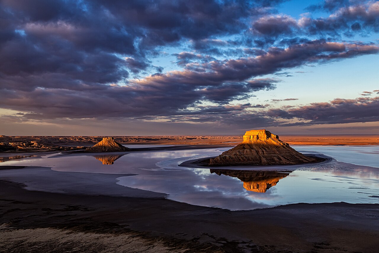
There is a photograph of Tuzbair that does the rounds every spring: white chalk cliffs standing over a perfectly still sheet of water, the whole escarpment doubled in the reflection. Then there’s the photograph nobody posts, which is the same place in August — a cracked grey-white crust stretching to the horizon, hot enough to see the air move. Both are Tuzbair. Which one you get depends almost entirely on when you show up.
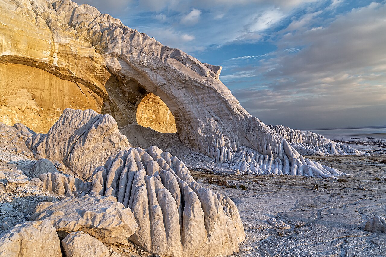
Tuzbair is a salt flat, or sor, in Mangystau region, western Kazakhstan, measuring roughly 15 km by 4 km beneath the chalk cliffs of the Ustyurt plateau. It holds shallow water from spring snowmelt and rain, producing a mirror effect, and dries to a hard salt crust by summer. It’s about 250 to 270 km from Aktau, with the last 40 km on dirt track.
Kyzylkup, the layered “tiramisu” hills, are the other half of this article. They sit 130 km south of Tuzbair on a completely different road, but they’re the same kind of thing — an ancient seabed carved open — and they’re the two stops that get left off most three-day itineraries. Here’s what they actually are, when to come, and why you should be careful about driving onto that beautiful white surface.
Tuzbair and Kyzylkup at a glance
| Tuzbair size | Roughly 15 km by 4 km, beneath cliffs over 60 m high |
| Tuzbair from Aktau | About 250–270 km, 4.5–5 hours; the last 40 km on dirt. South of Say-Utes on the Aktau–Beyneu road |
| Tuzbair elevation | Around +5 m. Despite the name and the look, it is not below sea level |
| Kyzylkup location | 43.608° N, 53.565° E, on the Aktau–Zhanaozen–Beket-Ata road, about 65 km from Zhanaozen |
| Kyzylkup from Aktau | About 230–250 km, with the last 5–7 km on unsigned steppe track |
| Mirror season | Spring — roughly late April into May, driven by snowmelt and spring rain. It’s a lottery |
| Dry season | Summer onwards. Hard white crust, muddy in the middle |
| Permits | None. Neither site is inside the Ustyurt Nature Reserve |
| Vehicle | 4×4 ideally; a crossover manages in dry weather. Never in rain |
| Facilities | None at either. No water, no shade, no signal, no settlements nearby |
What a “sor” actually is
This is the word that unlocks the place, and almost no English guide defines it.
A sor (Kazakh сор) is a closed, drainless depression characteristic of Central Asian deserts. Water collects in it and has nowhere to go: no river drains it, no outlet reaches the sea. So it floods seasonally into a shallow lake, becomes an inland salt marsh as evaporation concentrates the dissolved salts, and then dries out to a salt flat. Groundwater sits close to the surface all year, which is why the ground never fully hardens. The only plants that grow are halophytes — salt-tolerant scrub. Sors typically form in depressions no more than about a metre and a half deep.
Locals say “sor Tuzbair,” which is really “salt-flat salt-flat” once you know that tuz means salt. It’s worth distinguishing a sor from a takyr — Kazakh for “smooth” or “bare” — which is a clay-floored shallow depression that dries to a fissured crust. Takyr is the surface around Mount Bokty nearby. Sor is salt; takyr is clay. Both will bog a vehicle.
The geology: an old sea, and the cliffs above it
Tuzbair sits directly beneath the western escarpment — the chink — of the Ustyurt plateau. Those cliffs, over 60 metres high, are Cretaceous chalk and limestone laid down under the Tethys Ocean and later carved by wind and water. This is the brightest, whitest stretch of the whole plateau edge, which is exactly why the reflections work.
The area sat under the Paratethys, the Tethys’s shrinking remnant, until at least a few million years ago. Walk the slopes below the cliffs and you’ll find belemnites, ammonites, sea-urchin tests, petrified wood and, remarkably, the shark teeth of Parotodus mangyshlakensis — an extinct mackerel shark named for this peninsula. There is a shark named after the ground you’re standing on. Leave the teeth where they are.
Is Tuzbair below sea level? No — and here’s the correction
Every guide implies it, because “salt flat” plus “Caspian depression” adds up to below sea level in most readers’ heads. But elevation data for the flat’s floor returns about +5 metres, with the plateau rim above it running from 80 to 230 metres. Tuzbair is above sea level.
The site people are thinking of is Karagiye, the depression that bottoms out at −132 metres — the lowest point in Kazakhstan and in Central Asia, and the fifth lowest on Earth after the Dead Sea, Lake Assal, Turpan and Qattara. Karagiye is about 50 km from Aktau, roughly an hour’s drive, and about 130 km south-west of Tuzbair. They are separate day trips, not neighbours.
When does Tuzbair have water? The one fact that decides your trip
Spring melt and spring rain fill the pan into a shallow lake that mirrors the sky and the cliffs. By summer it has evaporated down to a walkable salt crust — though the middle stays muddy underneath, which matters more than it sounds.
The realistic window is late April into May, when the wild tulips are also out, with a small risk of night frost. April is the wettest month in the region, which is what makes it work, and also what makes the access track a gamble. The broader good-weather months are April, May, September and October.
Two honest caveats. First, this is genuinely a lottery: it depends on how much snow fell and how much rain arrived, and nobody publishes a forecast. Second, even in dry conditions the reflection sometimes survives as a thin residual film, and the ground stays viscous — one first-hand account describes the crust giving 10 to 15 centimetres underfoot, getting softer the further you walk from the cliffs. So “dry” does not mean “solid,” and a September visit can still yield a mirror.
Don’t drive onto the salt. Seriously.
This is the section I’d most like you to read twice.
The published warning is unambiguous: “the salt pan’s surface seems solid at first glance but under the upper crust, there is often a swamp.” Cars get stuck here regularly. A well-regarded guidebook author puts it as: don’t venture onto the salt flats with your car unless you’re an experienced off-roader — the area is prone to flash flooding and it’s easy to get stuck in sections of thick, salty mud.
The one hard number anyone publishes is useful: stay within about 200 metres of the cliffs, and follow existing tracks. Beyond that you’re on your own judgement and the crust gets thinner.
The flash-flood mechanism is the part that catches people out. Summer storms funnel water into a closed basin fast — that’s what a drainless depression does — and you can go from firm crust to bogged in minutes. A guide interviewed on the subject was blunt about it: it can be dangerous.
Walk it instead. Barefoot or in rubber boots, expect your shoes to sink, and accept that you’ll get salty and muddy. And when you’re back on tarmac, rinse the underside of the vehicle reasonably soon — salt plus moisture is hard on a chassis. That last bit is general practice rather than a local rule, but it’s the right instinct.
Getting to Tuzbair
From Aktau, take the A-33 north-east and turn off south of the village of Say-Utes (sometimes Otes) on the Aktau–Beyneu highway, then cover roughly 40 km of dirt track to the flat. Published distances vary — 230 km, 250 km, 270 km depending on route and who’s measuring, against a straight-line distance of 167 km — so the honest version is roughly 250 to 270 km and four and a half to five hours, with the last 40-odd kilometres unsealed. If you’re coming from an overnight at Sherkala or Airakty in the north, it’s only about 150 km.
There are three dirt approaches off the western chink. The nearest is at Kertt Spring (44.0332, 53.4100). Two others come in via Bagda Ravine (43.9488, 53.6131) and Baurbas Ravine (43.9391, 53.6922), both 15 km or more to the east. The clifftop panorama sits about a kilometre to a kilometre and a half from the Manat Pass — and the edges up there are steep and unfenced, which is a recurring theme in Mangystau and a recurring cause of accidents.
Download offline maps before you leave Aktau. There is no signage, no signal and no settlement nearby.
The arch, the sphinx and the saiga traps
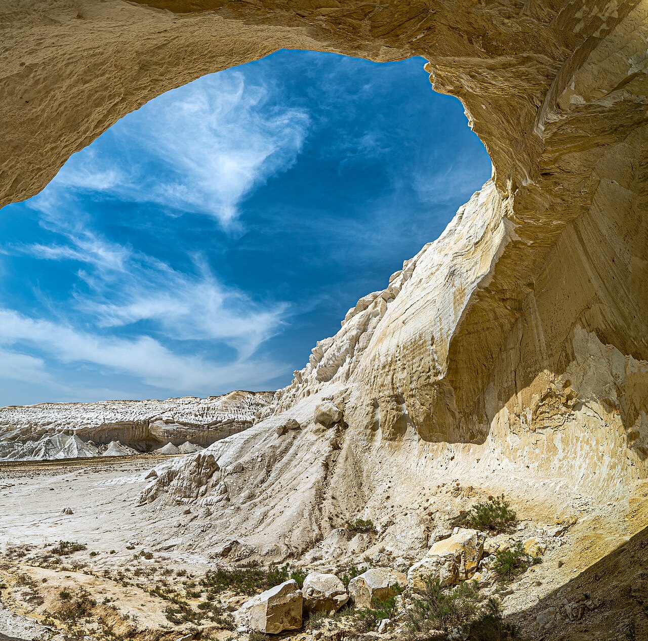
Tuzbair has more to look at than the flat itself. There’s a chalk arch over 15 metres high — the single most photographed feature here, framed against the white pan — and a butte that reads convincingly as the Sphinx at Giza from the right angle.
Then there are the arans: two nineteenth-century stone walls, built to funnel and trap saiga antelope, now designated historical monuments. They’re the same idea as the desert kites you find along the Bozzhyra rim, only very much more recent. Somebody stood here in the 1800s and built a wall to catch a migration. It’s worth pausing over.
Kyzylkup: the striped hills, and where they actually are
Let me correct something first, because I’ve seen it wrong repeatedly. Kyzylkup is not near Shetpe or Sherkala. It sits about 132 km south-south-east of Shetpe, on the Aktau–Zhanaozen–Beket-Ata road in the far south of the region. The town to orient by is Zhanaozen, roughly 65 km away.
The route: Aktau to Zhanaozen is about 150 km and two hours — fill up in Zhanaozen, it’s the last fuel. Then 70 to 80 km and an hour to an hour and a half to the turnoff, then 5 to 7 km and about twenty minutes on unsigned steppe track.
What the stripes are
The name is straightforward: kyzyl means red, kup means much or many. “Much red.” It’s a historical toponym that predates tourism entirely. The nickname “Tiramisu” is a guide-and-marketing invention from roughly the last five to seven years, and local operators are candid about that.
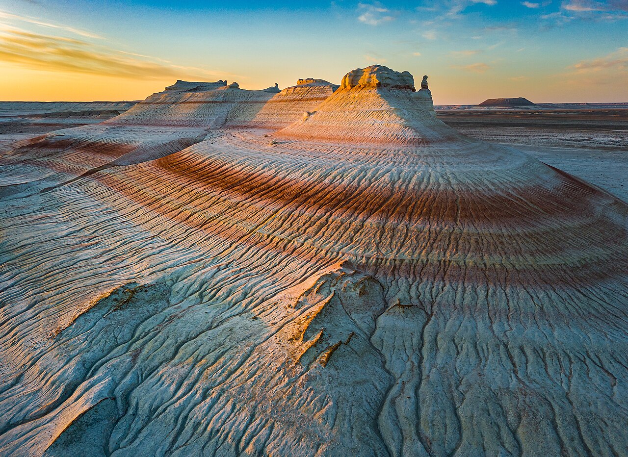
The bands are two different rocks laid down under different climates:
- Red — iron oxide in clay, deposited during a warmer, wetter, near-tropical period when iron in the water oxidised.
- White — pure chalk and limestone built from the shells of foraminifera, single-celled marine organisms, settling out during cooler, calmer intervals.
- Yellow and brown — mixed minerals in between.
So each stripe is a climate. You are reading a stack of ancient weather from a hillside.
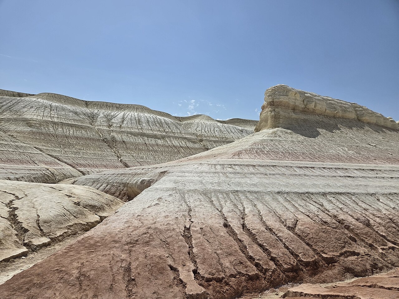
The rock itself is soft, loose, bentonite-rich clay, which is why Kyzylkup is all smooth rounded slopes rather than the cliffs and spires you get at Bozzhyra. It also explains the two rules that matter here: walk the hollows, not the ridgelines, because the crests crumble, and don’t drive on the hills at all — tyre tracks on this stuff last for years.
Photographing Kyzylkup — the light advice is contested
Here’s a rare disagreement worth flagging rather than resolving. One major operator says shoot golden hour, as you would anywhere. A photography-focused local guide argues the opposite and, having looked at the images, I lean their way: overcast or diffused light gives the deepest, most saturated clay colours, because direct sun blows out the pastel texture and flattens the bands. Evening side light also works well.
Their technical advice is specific and rings true: an 85–200 mm telephoto from 50 to 100 metres back to compress the stripes into a pattern, and a drone pointed straight down for the abstract version. Try both and see which you prefer — but don’t write off a grey day here.
The rain rule
If it’s raining, or has just rained, do not attempt Kyzylkup. Bentonite clay when wet is soap. The tread clogs in seconds and, in one guide’s memorable phrasing, even a prepared jeep loses control and becomes an uncontrollable sled. No tow truck is coming — the nearest help is Zhanaozen, 80 to 100-plus kilometres away.
The same warning applies to the takyr around Mount Bokty. In dry conditions a 4×4 is ideal and a crossover with decent clearance will manage; a low sedan risks its sump on sharp stones.
Bokty, and what else is nearby
Mount Bokty is 20 to 30 km from Kyzylkup — an isolated trapezoid roughly 165 m high standing on flat takyr at 43.4253° N, 53.8038° E. Its silhouette appears on the reverse of the 2006-series 1,000 tenge note, which makes it the most widely circulated image in Kazakhstan that nobody recognises. Note: I’ve seen “7 km” published for the Kyzylkup–Bokty distance and it doesn’t match the coordinates, which give closer to 28 km. Don’t plan around the shorter figure.
Other neighbours: Bozzhyra is 50 to 70 km away, and Beket-Ata 40 to 50 km, with Shopan-Ata passed on the drive in from Zhanaozen. That cluster — Kyzylkup, Bokty, Bozzhyra, the mosques — is genuinely well connected. Tuzbair, up in the north, is the odd one out.
Camping, wind and water
Tuzbair is a classic wild camp, and it rewards staying: the flat looks completely different in morning light, at midday, at sunset and under stars, and it’s worth a full day rather than a stop. There’s no light pollution for a hundred kilometres.
What to plan for:
- Wind. It gets up hard on an open pan with a cliff behind it. Bring windproof layers and stake everything properly.
- Cold nights, always. Even after a 40-degree day, the temperature drops fifteen to twenty degrees after dark.
- Water: 3 to 5 litres per person per day. There is no source at either site.
- No shade at Kyzylkup, at all. The iron-rich clay stores and re-radiates heat, so the ground acts like an oven — it’s described as dangerous to linger in by day in summer.
- Cliff edges are unfenced on the Tuzbair clifftop panorama.
Our Kazakhstan packing list covers the general kit. For these two, prioritise water, sun protection, windproofs and closed shoes you don’t mind ruining in salt mud.
Do you need a permit?
No. And it’s worth being precise, because Wikipedia’s English article on the Ustyurt Nature Reserve contains an error that circulates widely.
The Ustyurt Nature Reserve was established on 12 July 1984 and covers around 223,000 hectares, centred near 43.23° N, 54.65° E close to the Uzbek and Turkmen borders. That puts it roughly 147 km from Tuzbair and 97 km from Kyzylkup — so neither site is inside it, and neither requires a reserve permit. Entry to the reserve proper does need advance permission, which operators arrange.
The Wikipedia error to ignore: the English article claims Sherkala and Torysh lie within the reserve. They don’t — they’re around 250 km north of it, near Shetpe. And as of mid-2026 I could find no confirmed change to protected status or fees affecting Tuzbair or Kyzylkup, though Kazakhstan has announced a 2026–2035 biodiversity plan expanding protected land, so it’s worth a check before you travel. Our guide to Kazakhstan’s national parks and reserves explains how the different designations work.
Season by season
| Spring (Apr–May) | +20 to +25 °C, tulips and poppies out, and the only realistic chance of Tuzbair’s mirror. The risk is rain closing the tracks |
| Summer (Jun–Aug) | Up to +45 °C with no shade at either site. Tuzbair is dry crust; Kyzylkup is dangerous to linger in. Flash-flood risk from storms |
| Autumn (Sep–Oct) | Dry, golden and the safest roads of the year. The best all-round window if you don’t need the reflection |
| Winter (Nov–Mar) | Off-season. Squall winds, clay turning to slush, access failing even for jeeps |
See Kazakhstan in spring if you’re chasing the mirror and the tulips together, and the best time to visit Kazakhstan for how this fits the rest of the country.
How these fit a Mangystau itinerary
The standard three-day loop from Aktau runs: Day 1, Torysh, Kok-Kala, Sherkala and Airakty with a camp at Airakty; Day 2, across to Bozzhyra for the rim viewpoints and camp on the valley floor; Day 3, the Fangs, then Bokty and Kyzylkup, lunch in Zhanaozen and back to Aktau.
Which means Kyzylkup fits neatly and Tuzbair doesn’t. Tuzbair sits in the northern half of the region and needs either a fourth day or a different shape — approaching it from a Sherkala or Airakty overnight cuts the drive to about 150 km, which is the sensible workaround.
One routing tip worth stealing from a local photography guide: take Kyzylkup at midday when diffused or high light suits it, keep Bokty for golden hour, and then sleep at Bozzhyra or the Beket-Ata guesthouse — not at Bokty, where there’s wind and no shelter of any kind.
For the full regional picture, start with our Mangystau and the west pillar. Aktau is the base at either end, Torysh and Sherkala is the northern day, and if you’re weighing self-drive, read renting a car in Kazakhstan — the Aktau rental contracts have very specific things to say about salt flats.
Frequently asked questions
What is a sor in Kazakhstan?
A closed, drainless depression typical of Central Asian deserts. Water collects with no outlet, so the basin floods seasonally into a shallow lake, becomes a salt marsh as it concentrates, then dries to a salt flat. Groundwater stays near the surface, which is why the ground remains soft under the crust.
Where is the Tuzbair salt flat?
In Mangystau region, western Kazakhstan, beneath the western escarpment of the Ustyurt plateau, south of the village of Say-Utes on the Aktau–Beyneu highway. It’s roughly 250–270 km from Aktau, with the final 40 km on dirt track.
Is Tuzbair below sea level?
No — elevation data puts the flat’s floor at around +5 m. The below-sea-level site people are thinking of is Karagiye, at −132 m, which is about 50 km from Aktau and 130 km from Tuzbair.
When does Tuzbair have water and give a reflection?
Spring, driven by snowmelt and spring rain, with late April into May the realistic window. By summer it evaporates to a walkable crust, though the middle stays muddy and a thin residual film can still mirror. It varies year to year and nobody forecasts it.
Can you drive on the Tuzbair salt flat?
You shouldn’t. The crust looks solid but there is often swampy mud underneath, and vehicles get stuck regularly. Stay within about 200 metres of the cliffs, follow existing tracks, and walk out rather than drive. Flash flooding from summer storms can bog a vehicle in minutes.
Why are the Kyzylkup hills striped?
Because each band was laid down under a different climate. The red layers are iron oxide in clay from a warmer, wetter period; the white are chalk and limestone built from foraminifera shells during cooler, calmer intervals; the yellows and browns are mixtures. The soft bentonite clay is why the hills are rounded rather than cliffed.
Why is Kyzylkup called the Tiramisu?
It’s a nickname invented by guides in roughly the last five to seven years, because the layered red-and-cream bands look like the dessert. The real name is older and plainer: kyzyl red, kup much — “much red.”
Do you need a 4×4 for Tuzbair and Kyzylkup?
A 4×4 is ideal. A crossover with decent ground clearance manages in dry weather; a low sedan is a bad idea on sharp stones. In wet weather neither is viable — bentonite clay becomes genuinely uncontrollable, and no recovery is coming.
Do you need a permit for Tuzbair or Kyzylkup?
No. Both sit well outside the Ustyurt Nature Reserve — roughly 147 km and 97 km away respectively — so no reserve permit or fee applies. The reserve itself does require advance permission, usually arranged by operators.
Can you camp at Tuzbair?
Yes, and it’s the best way to see it, since the flat changes character completely through the day and the night sky is exceptional. Bring all your water, windproof layers and warm clothes for the night, and camp well back from the unfenced clifftop edges.
Will there be mobile signal?
No, at either site. Download offline maps before leaving Aktau or Zhanaozen, carry route coordinates rather than relying on live navigation, and tell someone your plan.
How do these fit into a three-day Mangystau trip?
Kyzylkup fits neatly onto day three of the standard loop, alongside Bokty on the way back to Aktau from Bozzhyra. Tuzbair does not fit a strict three-day loop — it sits in the north and needs a fourth day, or an approach from a Sherkala or Airakty overnight, which shortens the drive to about 150 km.
Final thoughts
Tuzbair and Kyzylkup are the two Mangystau sites that get cut when time is short, and they’re the two I’d fight to keep. Bozzhyra is spectacular in an obvious way. These are quieter: a white pan under a white cliff that may or may not be holding a sky, and a hillside where you can read a hundred million years of climate in stripes.
If you want the mirror, come in late April or May and accept that you might not get it. If you want reliability, come in September or October, and take the crust and the colours as they are. Either way: walk out rather than drive, keep off the ridgelines at Kyzylkup, watch the sky for storms, and carry more water than you think you need.
And if it rains, turn round. That clay does not negotiate.
Photo credits
Chalk arch above the Tuzbair salt flat at golden hour — Photo: Astrobond / CC BY-SA 4.0 via Wikimedia Commons. Looking out through the Tuzbair arch — Photo: Максат79 / CC BY-SA 4.0 via Wikimedia Commons. Dawn on the Kyzylkup hills — Photo: Максат79 / CC BY-SA 4.0 via Wikimedia Commons. Kyzylkup clay and chalk bands close up — Photo: IvarT / CC0 via Wikimedia Commons. The Three Brothers reflected in the Karynzharyk depression — Photo: Astrobond / CC BY-SA 4.0 via Wikimedia Commons.


