Contents
- Bozzhyra at a glance
- Where Bozzhyra actually is, and why that matters
- The geology, briefly, because it explains the colour
- The two tiers: the single most useful thing to understand
- Do you really need a 4×4?
- Is Bozzhyra protected? The permit question, answered properly
- What changed in 2026 — and what to expect on arrival
- When to go, month by month
- Light, and the timing trap in day tours
- Camping, water and the practical minimum
- What it costs
- Safety: the drops are the real risk
- Was Star Wars filmed here? No. Was anything?
- How Bozzhyra fits a longer trip
- Frequently asked questions
- Final thoughts
The first time I stood on the rim above Bozzhyra I understood why everyone reaches for other planets to describe it. It isn’t the scale, exactly — plenty of places are bigger. It’s that the whole scene is the wrong colour. Chalk-white spires and flat-topped mesas standing in a bone-pale basin, and beyond them a salt flat so bright it reads as water. Nothing green, nothing vertical that isn’t rock, and no sound at all.
Bozzhyra is a chalk canyon on the western edge of the Ustyurt plateau in Mangystau region, western Kazakhstan, about 270 km from Aktau. Its landmark formation is a pair of pinnacles the Kazakhs call Azu Tisteri, “the fang teeth.” Getting there takes four to five hours by 4×4, there is no entrance fee, and there is no water, no signal and no rescue.
That last sentence is the whole trip in miniature. Bozzhyra is genuinely one of the great landscapes of Central Asia, and it is also a long, hot, unsupported drive into an empty quarter of a very large country. This guide covers the parts that actually determine whether you enjoy it: which viewpoint you’re standing on, what a 4×4 is really for, when the light works, what it costs in tenge and in dollars, and what changed in 2026 — because a sealed road and a visitor centre are being built as I write, and almost nothing published in English mentions them.

Bozzhyra at a glance
| Where | Western edge of the Ustyurt plateau, Karakiya district, Mangystau region — roughly 43.42° N, 54.07° E |
| From Aktau | About 270 km, 4–5 hours. Asphalt almost the whole way, then roughly 5 km of dirt to the first viewpoint |
| Between viewpoints | About 60 km of unsigned dirt track, including a steep descent to the valley floor |
| Entrance fee | None. No permit needed either (unlike neighbouring Karynzharyk) |
| Vehicle | 4×4 with real ground clearance. Not a 2WD sedan job |
| Best months | April–May and September–October, roughly +15 to +25 °C |
| Worst months | June–August (up to +45 °C, zero shade) and deep winter (below −10 °C with gales) |
| Facilities | None on site as of July 2026 — no water, no toilets, no shop, no mobile signal |
| Typical cost | 15,000–45,000 KZT per person on a local group day tour; US$180–495 per person on a foreign-facing private day tour |
| How long you need | One long day works. One night camping is much better |
Where Bozzhyra actually is, and why that matters
Bozzhyra sits on the western escarpment of the Ustyurt plateau, a vast tableland of about 200,000 km² spread across Kazakhstan, Uzbekistan and Turkmenistan. Ustyurt averages only around 150 m in elevation, but it is ringed by steep cliffs the locals call chinks, and those cliffs are the point. Bozzhyra is where a chink has been eaten back into a wide amphitheatre, leaving isolated chalk outliers standing on the basin floor like the last teeth in an old jaw.
The name itself is plain description: Bozzhyra means roughly “grey ravine” or “grey-blue depression” in Kazakhstan. You’ll see it spelled Bozzhyra, Bozjyra, Boszhira and Bosjira depending on who transliterated it, and all four refer to the same place. If you’re searching maps or Wikimedia, try more than one.
The distances are the thing people get wrong. From Aktau it’s around 270 km, which sounds like three hours in most countries. Here it’s four to five, and a one-day round trip out of Aktau totals roughly 590 km — about 530 km of asphalt plus 60 km of off-road — which means nine or more hours in a vehicle for perhaps an hour on the rim. From Zhanaozen the figure is quoted anywhere between 148 km and 240 km depending on which track you take, so I’d rather tell you the range than pretend there’s one answer. Shetpe, the nearest town with beds, is about 70 km away, of which the last 50 km is dirt.
None of it is signposted. There are no markers, no arrows, no “viewpoint 2 km” boards. Download offline maps before you leave Aktau — Organic Maps carries a surprising number of the Mangystau jeep tracks — and if you’re driving yourself, get GPS coordinates for each viewpoint rather than trusting a route line.
The geology, briefly, because it explains the colour
All of this was seabed. The Tethys Ocean covered western Kazakhstan, and when it withdrew it left chalk — the compacted remains of shells, skeletons and marine mud — in beds reported at up to 250 m thick. Tectonic uplift then raised the whole plateau, and wind and rain have been cutting it apart ever since. What you’re looking at is an erosional landscape still actively falling apart, which is exactly why the cliff edges are so dangerous.
Structurally, the formations are caps of harder reddish sandstone sitting on softer water-worn chalk. The sandstone protects what’s underneath; where the cap has gone, the chalk melts away into those fluted, drapery-like slopes. The core cluster of formations packs into an area of roughly 7 km by 7 km.
Look down while you walk. Fossil sea urchins and belemnites turn up on the ground at the base of the cliffs — belemnites being the bullet-shaped internal skeletons of squid relatives that died out with the dinosaurs. Leave them where they are; a landscape that gets 40,000 visitors a year cannot spare a fossil each.
The named formations are worth learning, because guides use the Kazakh names and the English ones are inventions:
- Azu Tisteri — “fang teeth,” the twin pinnacles on every photograph of Bozzhyra. North and south fangs, around 43.4168° N, 54.0725° E.
- Ushkir Tau — usually rendered “Dragon’s Crest.” A ridge with four peaks, roughly 600 m long, narrowing to about 20 m across at the top, with sheer drops both sides.
- Borly Tau — a flat-topped chalk mountain reported at about 190 m high, 329 m long and 60 m wide.
- Ulken Keme and Shoky Tau — further outliers on the basin floor, sometimes pointed out as “the ship” and similar.
One more thing, and it’s a good one: along the cliff edges there are hundreds of stone structures known as desert kites — long converging walls built as hunting traps, thought to be around 2,000 years old. People have been using this landscape for a very long time. You are not the first person to stand on that rim and think about how to get down.
The two tiers: the single most useful thing to understand
Almost every guide I’ve read describes Bozzhyra as one place with “three viewpoints.” That’s technically true and practically misleading. What actually exists is two different levels of the same canyon, separated by a hundred-metre-plus escarpment and about fifteen kilometres of track, and you cannot properly see one from the other.
The upper tier is the plateau rim. You drive off the highway, cover a few kilometres of dirt, and walk out onto the edge. This is where you get the wide view: the whole basin laid out below you, the outliers small and sculptural, the salt flat glaring in the distance. The first stop, often called the Martian Panorama, is about 5 km off the road. Dragon’s Crest is roughly 6 km further south along the rim, on a high cliff, and is the one most photographers rate highest in all of Mangystau.
The lower tier is the valley floor and the approach to the Fangs. Getting there means a further drive — quoted at around 40 km, including a steep descent off the escarpment — then a transfer of about 15 km along the basin, then a walk of roughly a kilometre with maybe 100 m of climbing to reach the viewpoint. Down here the formations tower over you instead of sitting below you. It’s a completely different photograph and a completely different feeling.
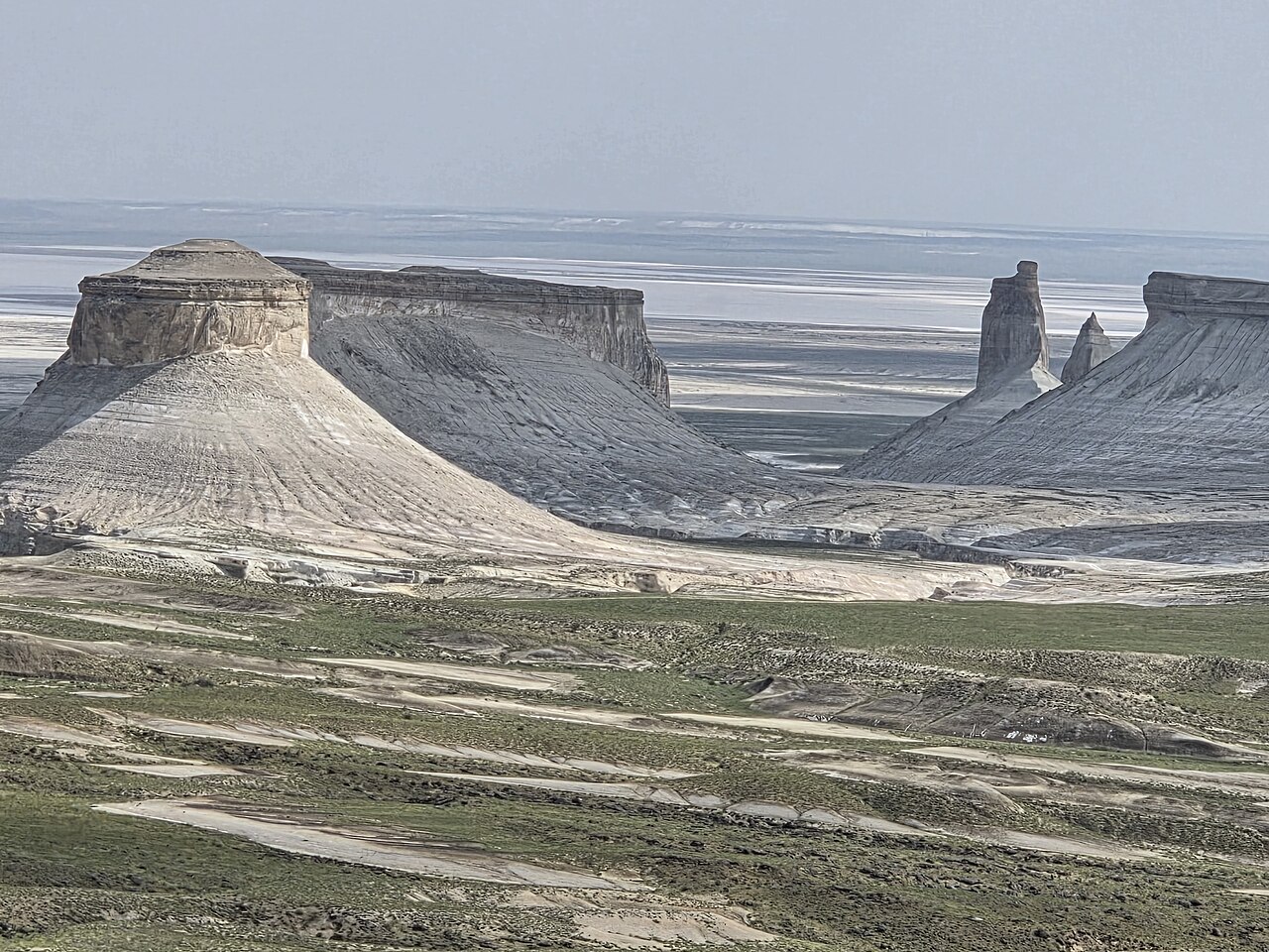
If you only have a few hours, take the upper rim: it’s far quicker to reach and it’s the view that explains the place. If you have a full day or you’re camping, do both, and do the lower tier in the good light. Guidebook writers who know the area well point out that the best overall vantage is from the Western Chink, which stands a couple of hundred metres above the main peaks — in other words, the rim looks down on everything, and the valley floor is where you go to feel small.
How many viewpoints are there? Depends who’s counting. Three are developed and visited on standard tours; five are viable along the chink if you know where to stop. Don’t get attached to a number.
Do you really need a 4×4?
Yes, and here is the honest version of why.
The asphalt now runs to within about five kilometres of the first viewpoint. If your only ambition were to stand on the upper rim in dry weather, the terrain argument would be thinner than people make it sound. But the trip nobody actually wants is only the first viewpoint, and the moment you commit to the inter-viewpoint circuit you’re on roughly 60 km of unsealed track including a descent off the escarpment. That track is dust in high summer, rock in places, deep sand in others, and after rain some sections are simply impassable. Wind reshapes the sandy stretches, so a line that worked last month may not exist now.
I have not found a single documented account of anyone attempting it in a 2WD, which tells you something about the local consensus. What I can tell you is that people with proper vehicles still get stuck — one writer bogged in mud out here after November storms — and the nearest settlement is 70 km away with no phone signal in between. Guided operators carry recovery gear and spare fuel. That is not an upsell; it is the actual reason to consider going guided.
If you self-drive, carry spare fuel, more water than you think you need, a spare tyre you’ve checked, recovery equipment, and food to be genuinely self-sufficient. And tell someone your route before you lose signal.
Is Bozzhyra protected? The permit question, answered properly
This gets stated wrongly in both directions online, so here’s the position as best I can establish it.
Bozzhyra is not part of the Ustyurt State Nature Reserve. The Mangystau regional administration confirmed in January 2025 that the tract would not be added to it. The reserve itself was created in July 1984 and covers around 223,000 hectares further south, near the Uzbek and Turkmen borders, with plans to set aside a further 640,000-odd hectares.
Bozzhyra is nevertheless inside protected land at oblast level — specialists place it within the Zhabayushkan zakaznik and the Kyzylsai nature park, and the area holds red-listed species including urial, goitered gazelle, Egyptian vulture and saker falcon. In practice, for a visitor, that means: no ticket office, no entrance fee, no permit, and camping is allowed.
The important exception is Karynzharyk, the neighbouring depression with the “Three Brothers” outliers. That one sits close to the Turkmen border inside the reserve proper and does require a Ustyurt Nature Reserve permit, which tour operators normally arrange for you. If a self-drive itinerary includes Karynzharyk, sort the paperwork before you go. And be careful with the phrase “Bozzhyra National Park” — you’ll see it in print, but I could find no evidence that any national park of that name exists.
What changed in 2026 — and what to expect on arrival
This is the part that isn’t in the guidebooks yet. Bozzhyra is being built.
A 14.9 km sealed access road to the viewpoint is under construction at a reported cost of about 3.2 billion tenge. Work began in January 2026 and, as of the last progress report I could find dated 31 May 2026, the subgrade was finished with sand-gravel laid on 11 of the 14.9 km. I cannot confirm whether it is open. Assume dirt, and be pleasantly surprised.
A visitor centre beside the access road was reported complete on 15 April 2026 — around 200 m², capacity roughly 100 people at a time, with food service, local crafts and guidebooks, plus a tent campsite with toilets, washrooms and showers. It was due to open in May 2026. Again: completion is confirmed, opening is not, and no fee has been published. Don’t plan your water supply around it.
Beyond that, three formal viewing platforms linked by graded walking trails are budgeted at about 1 billion tenge for delivery by 2027 under the Mangystau tourism zone plan for 2025–2029, and a separate privately funded complex — 17 glamping pavilions, 50 hotel rooms, a visitor centre of up to 450 m² and an ethnic-style café — had its foundation ceremony at the gorge in April 2025 with commissioning targeted for 2027.
All of which arrives after a long fight. A Turkish investor began building a hotel and ethno-park at Bozzhyra in 2021, was pushed by public outcry into moving it four kilometres away, and in December 2024 the regional governor announced the project cancelled. Back in December 2020, President Tokayev had ordered the original scheme revised after a public appeal. Kazakhs care about this landscape, loudly, and that is worth knowing before you leave a wrapper behind.
For balance, here is a Kazakh newspaper’s assessment of what is actually on the ground in 2026: “an absolute infrastructure vacuum — there is no signal, no roads, no toilets, not even paid ones.” Then the same piece concludes that if you endure the drive and see the sunset from the rim, you’ll decide it was worth every tenge. Both halves are true.
When to go, month by month
April–May and September–October. Everything else is a compromise.
In the shoulder seasons you get daytime temperatures around +15 to +25 °C, and in spring the steppe briefly greens and flowers. April is also the wettest month in the region, which is a small figure in absolute terms — the nearest weather station at Zhanaozen records about 13 mm — but rain is what turns the tracks to grease, so a wet week can cost you the lower viewpoints entirely.
Summer is the problem. July at Zhanaozen averages a daily high around 34 °C and can reach the mid-forties on the plateau, with no shade of any kind and no water source. Skies are clearest in July, which is lovely for photographs and unhelpful for your body. If you must go in summer, start before dawn and be off the rim by late morning.
Winter drops to around −8 °C overnight in January with strong winds, and the risk is not the cold so much as the weather closing in. One writer visiting in November lost almost every viewpoint to gale-force wind, rain and snow and got about five minutes at Dragon’s Crest. Whatever month you pick, bring warm layers: desert temperatures fall away fast after sunset, every time.
If you’re still choosing dates for the wider trip, our guides to Kazakhstan in spring and Kazakhstan in autumn set Mangystau against what the rest of the country is doing, and the best time to visit Kazakhstan overview covers the trade-offs in one place.
Light, and the timing trap in day tours
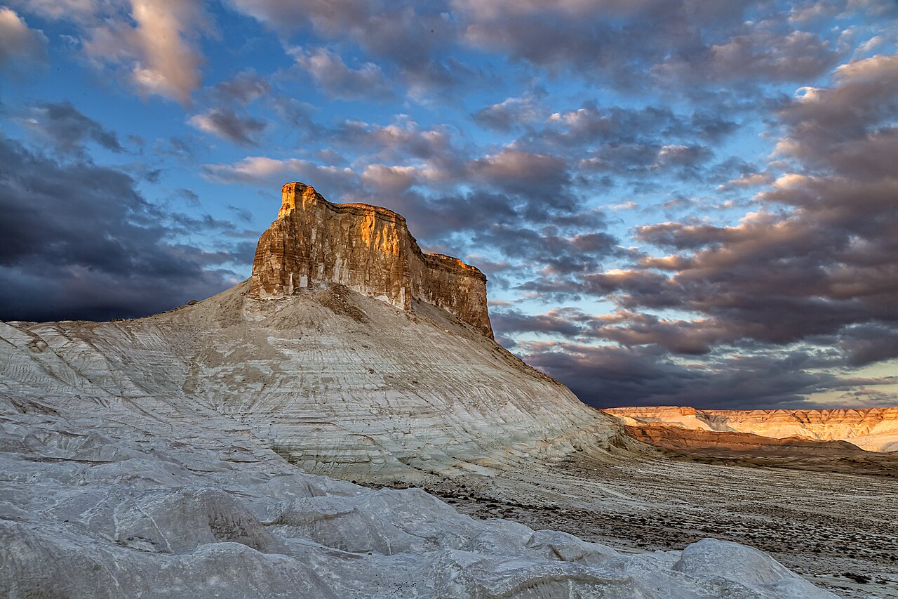
Bozzhyra is a golden-hour landscape and a midday disappointment. At sunrise the chalk goes soft pink and lilac; at sunset it turns properly golden-red while the basin sinks into shadow; in the middle of the day it flattens to a harsh white-and-yellow glare that no camera handles well.
Now look at the schedule of a typical one-day tour from Aktau: leave early, reach the site around 12:30 to 13:30, and start back by about 16:00. That is the worst light of the day, by some margin. If photographs are the reason you’re going, you need to camp — and if you camp, the night sky out here is among the best in Kazakhstan, with effectively no light pollution anywhere near.
Which of sunrise or sunset is better? No source I trust ranks them, and I’m not going to invent a rule. Camp and shoot both.
Camping, water and the practical minimum
There are no hotels at Bozzhyra and, as of July 2026, no official campsite beyond whatever the new visitor centre opens with. Wild camping is permitted and is simply how people overnight in Mangystau. The usual pitches are near Dragon’s Crest on the rim or on the basin floor near the Fangs.
What that means in practice:
- Water: carry it all. Three to five litres per person per day, minimum, and more in summer. There is no source.
- Food: carry it all. No shops, no cafés, nothing between the last town and the rim.
- Fuel: fill up in Zhanaozen and carry a spare can.
- Campfires: prohibited. Bring a stove.
- Signal: none. No mobile, no internet. Leave your plan with someone.
- First aid: a proper kit. The nearest settlement is about 70 km away and there is no medical help closer.
- Wind: stake everything properly and expect it to get up overnight.
Nearest actual beds are Shetpe, around 70 km and an hour and a half to two hours away, or Aktau at roughly 300 km. Our Kazakhstan packing list covers the general kit; for Bozzhyra specifically, add a sun hat you can’t lose in wind, more water than feels sensible, and a headtorch.
What it costs
Two markets exist here and they don’t price the same trip the same way. All figures below are dated, because tenge prices move; the rate I’m using is roughly 477 KZT to the US dollar in late July 2026.
| Local group day tour | 15,000–45,000 KZT per person (about US$31–94), quoted June 2026 |
| Local two-day trip with a night in tents or a guesthouse | 60,000–120,000 KZT (about US$126–252), June 2026 |
| Local private day tour, per vehicle | From around 100,000–160,000 KZT for up to four people, 2026 |
| Foreign-facing private day tour | US$495 for one person, US$260 each for two, US$180 each for three, US$235 each for four — 2026 rates |
| Aktau hostel bed | 5,000–10,000 KZT a night |
| Aktau mid-range hotel room | 25,000–60,000 KZT a night |
| 4×4 self-drive | From about 25,000–30,000 KZT a day locally; US$230–280 a day from expedition-kitted operators |
Two things jump out. First, the gap: a local group seat can be three to four times cheaper than the international equivalent for broadly the same day, and the difference buys you an English-speaking guide, insurance and a booking you can make from abroad. Decide which of those you actually need. Second, that odd four-person figure — on most operators a fourth traveller costs more per head than three, because vehicles cap at three passengers and a fourth triggers a second car.
For historical context, a one-day off-road trip started at 80,000 tenge — about US$180 per car, not per person — in July 2023. The market has moved a long way in three years. There’s more on this in our Kazakhstan trip cost breakdown, and if you’re pricing the wider country, organised tours in Kazakhstan covers what guided travel buys you elsewhere.
One practical warning: there are no ATMs outside Aktau city. Draw cash before you leave, and expect some local operators to prefer it.
Safety: the drops are the real risk
I don’t want to be dramatic about this, but Bozzhyra kills people who treat it as a photo backdrop. The rims are unfenced, the drops are over a hundred metres, and the rock at the very edge is friable chalk that can and does give way. Add the wind — which is frequently strong and gusty on an exposed plateau edge — and stepping out for a better angle is a genuinely bad idea. Local guides ask visitors not to approach the edge at all, and some operators screen bookings for heart conditions, asthma and blood pressure because the walk involves real ascents and descents in heat.
For scale: in November 2022 the Estonian slackliner Jaan Roose walked a 500 m line strung roughly 200 m above the ground between two Bozzhyra hills. Two hundred metres of air. That’s what you’re standing above.
Two more things. Driving onto the formations themselves is prohibited and damages a surface that doesn’t recover — stay on established tracks. And the blunt-nosed viper, gyurza, one of Kazakhstan’s most venomous snakes, lives in the region. It avoids people, but watch where you put your hands on warm rock. Our is Kazakhstan safe guide covers the general picture; Mangystau’s specific risk is simply remoteness.

Was Star Wars filmed here? No. Was anything?
Let’s settle this, because both claims circulate locally and neither is true.
Star Wars was never filmed at Bozzhyra, or anywhere in Kazakhstan. The documented desert locations for the franchise are Tunisia, Wadi Rum in Jordan, Norway, Ireland, Guatemala, Abu Dhabi and Death Valley. Kazakhstan appears on no official location list. “Star Wars was shot here” is a myth that attaches itself to photogenic desert sites worldwide — Tunisia’s Ksar Ouled Soltane and Cappadocia get the same treatment.
Dune wasn’t filmed here either, despite the rumour being repeated by guides and at least one major travel site as local lore. Denis Villeneuve’s films shot in Wadi Rum, Liwa in the UAE, Budapest and Norway.
What is true is better anyway. Principal photography for the international feature Armour of God: Ultimatum, starring Jackie Chan and directed by Robert Kun, began at the Bozzhyra tract on 18 July 2026 — eleven days before I’m writing this — with a slate-breaking ceremony on site. And in February 2026 The Telegraph named Bozzhyra one of the ten deserts to see in your lifetime, in company with the Sahara, Atacama, Namib and Wadi Rum. Bozzhyra doesn’t need a borrowed film credit.
How Bozzhyra fits a longer trip
Almost nobody flies to Aktau for Bozzhyra alone, and you shouldn’t either. The standard three-day loop out of Aktau runs the northern cluster first — the stone spheres at Torysh, the yurt-shaped dome of Sherkala, the castle skyline of Airakty — camps, crosses to Bozzhyra for the rim viewpoints, camps again, then takes in the Fangs, Bokty and the striped hills of Kyzylkup on the way home. Five days lets you add the Tuzbair salt flat and the underground mosques; a week opens up Beket-Ata, Shakpak-Ata and the far Ustyurt.
Our regional pillar, Mangystau and western Kazakhstan, sets out the whole region and how the clusters connect. If Bozzhyra is the reason you’re coming to the country at all, it slots naturally into a ten-day Kazakhstan itinerary alongside Almaty and the mountains, and it belongs on any honest list of the most beautiful places in Kazakhstan or Kazakhstan off the beaten path. If you’re weighing whether the whole trip is worth it, we’ve argued that out in is Kazakhstan worth visiting.
Getting to Aktau itself is easy enough — it’s well served from Almaty and Astana and increasingly from Istanbul, Dubai and Baku. See flights to Kazakhstan and domestic flights within Kazakhstan. Most visitors need nothing more than a passport for a 30-day stay; check Kazakhstan visa requirements for your nationality. And if you’re contemplating driving yourself, read renting a car in Kazakhstan first — the rental contracts have opinions about desert driving.
Frequently asked questions
How do you get to Bozzhyra from Aktau?
Drive south-east on good asphalt towards Zhanaozen, then continue on to the plateau, with roughly the last five kilometres on dirt to the first viewpoint. It’s about 270 km and four to five hours one way. There is no public transport to Bozzhyra, or to any of Mangystau’s natural sites — buses and shared taxis link Aktau with Zhanaozen and Fort-Shevchenko and stop there.
Do you need a 4×4 to visit Bozzhyra?
For anything beyond the first rim viewpoint, yes. The asphalt reaches within about five kilometres of the upper viewpoint, but the roughly 60 km circuit between viewpoints and the descent to the valley floor need a high-clearance 4×4 and, ideally, someone who has driven it before. After rain, sections become impassable regardless of vehicle.
Do you need a permit or ticket for Bozzhyra?
No. There’s no entrance fee, no ticket office and no permit requirement, and camping is allowed. The neighbouring Karynzharyk depression is different — it sits inside the Ustyurt Nature Reserve near the Turkmen border and does need a permit, which operators normally arrange.
How long do you need at Bozzhyra?
A day trip from Aktau works but gives you roughly an hour on site, in the worst light of the day, after nine hours in a car. One night camping transforms it: you get sunset, the stars and sunrise, and time for both the rim and the valley floor. Two nights lets you cover the wider tract without rushing.
What is the best time of year to visit Bozzhyra?
April to May and September to October, when daytime temperatures sit around +15 to +25 °C. Summer regularly exceeds +40 °C with no shade or water; winter brings sub-zero nights and gales that can wipe out your viewpoints.
Can you camp at Bozzhyra?
Yes, and it’s the normal way to overnight here. Wild camping is permitted, there’s no charge, and the usual spots are near Dragon’s Crest on the rim or on the basin floor near the Fangs. Bring everything — water, food, fuel, a stove, because campfires are prohibited — and camp well back from cliff edges.
Is there mobile signal at Bozzhyra?
No. There’s no mobile coverage and no internet in the tract. Tell someone your itinerary before you leave the last town, and don’t rely on being able to call for help.
How much does a Bozzhyra tour cost?
Local group day tours ran from about 15,000 to 45,000 tenge per person in mid-2026. Foreign-facing private day tours were priced at US$495 for a solo traveller, about US$260 each for two and US$180 each for three. Two-day trips with a night camping ran roughly 60,000–120,000 tenge locally.
What are the Fangs of Bozzhyra called in Kazakh?
Azu Tisteri, which translates as “fang teeth.” The neighbouring ridge often marketed as Dragon’s Crest is Ushkir Tau. You’ll also hear Borly Tau, Ulken Keme and Shoky Tau for other formations in the basin.
Where do you stay near Bozzhyra?
Camping on site, or hotels in Shetpe about 70 km away, or Aktau at roughly 300 km. A visitor-centre campsite with toilets and showers was completed in April 2026 and due to open that May, and glamping pavilions and hotel rooms are planned at the gorge for 2027 — but as of July 2026 I’d plan on a tent.
Final thoughts
Bozzhyra is the rare place that survives its own photographs. You’ve probably already seen the Fangs at sunset a dozen times on somebody’s feed, and the picture still doesn’t prepare you for standing on that rim in complete silence with a hundred metres of nothing under your toes and a white seabed stretching to the horizon.
It also asks a lot. Nine hours of driving for one hour of view, if you do it the easy way. No water, no signal, no help. A landscape actively falling apart under your feet, and a construction programme that will have changed the arrival experience by the time you read this.
My advice, honestly, is to give it a night. Take the rim in the evening, sleep out, walk into the basin at first light, and let the place work at its own pace. Then drive back to Aktau and try to explain it to someone. You won’t manage it, which is rather the point.
Photo credits
Bozjyra’s Fangs on the Ustyurt plateau — Photo: Dylanvt / CC BY-SA 4.0 via Wikimedia Commons. View from the upper plateau-rim viewpoint — Photo: IvarT / CC0 via Wikimedia Commons. Chalk butte in the Bozzhyra tract at last light — Photo: Astrobond / CC BY-SA 4.0 via Wikimedia Commons. Hiking the chalk cliffs of Bozzhyra — Photo: Sergio Agostinelli / CC BY 2.0 via Wikimedia Commons.


