Contents
- Torysh and Sherkala at a glance
- Getting to the Valley of Balls
- What the stone balls actually are
- Are they dinosaur eggs? No. Here’s the argument that settles it
- Other places on Earth with stone spheres
- Please don’t break them
- Sherkala: the mountain that looks like a yurt, or a lion, or a teacup
- What else is on the same route
- Do you need a 4×4? The genuinely unresolved question
- When to go, and what a day costs
- Frequently asked questions
- Final thoughts
You come over a low rise on the Aktau road and there they are: hundreds of stone spheres scattered across bare steppe like something spilled. Some the size of a marble, some the size of a small car, a few half-buried and slowly emerging from the ground as the softer rock around them wears away. It looks staged. It absolutely isn’t.
The Valley of Balls, Torysh, is a field of spherical stone concretions on the steppe of Mangystau region, western Kazakhstan, about 100 km north of Aktau. They are natural — mineral cement built up in onion-like layers around a nucleus inside marine sediment, then exposed as the surrounding rock eroded. There’s no entrance fee, and most people visit alongside Sherkala mountain nearby.
The two go together for a practical reason: Torysh, Sherkala and the Valley of Castles at Airakty sit within about 60 km of each other and make a natural single day out of Aktau. What follows covers the real geology — including why the dinosaur-egg story keeps coming back and why it’s wrong — the genuinely contested question of whether you need a 4×4, and how tall Sherkala actually is, which almost every page online gets wrong.

Torysh and Sherkala at a glance
| Torysh from Aktau | About 100–105 km, 2–2.5 hours. Roughly 95 km of asphalt towards Taushyk, then 7–8 km of dirt |
| Sherkala from Aktau | About 170–180 km, roughly 3 hours; 18–22 km north-west of Shetpe |
| Torysh to Sherkala | About 60 km east |
| Sherkala height | 307 m above sea level, around 150 m above the surrounding steppe (not the 332 m you’ll see quoted) |
| Sphere sizes | From marbles to roughly 4 m across |
| Entrance fee | None at Torysh, Sherkala or Airakty. No ticket office exists |
| Protected status | Torysh has none, despite being extremely fragile |
| Vehicle | High clearance strongly advised; sources genuinely disagree on whether 4×4 is essential |
| Best months | April–May and September–October |
| Facilities | None. No signal, no signage, no water, no viewing platforms. Nearest shops in Shetpe |
| Time needed | An hour at Torysh; an hour to walk round Sherkala’s base; both plus Airakty is a full day |
Getting to the Valley of Balls
From Aktau you head roughly 100–105 km north on paved road towards the village of Taushyk (you’ll also see it as Tauchik or Tau-Chik), turn off, and cover the last seven or eight kilometres on dirt track to reach one of the clusters. Local operators put the whole run at 100 km and two to two and a half hours, with the tarmac holding for about 95 km.
From Shetpe, the small town that functions as the practical gateway for this corner of Mangystau, it’s about 40 km and an hour on dirt. From Zhanaozen, in the south, it’s around 160 km and three to three and a half hours.
One thing worth understanding before you go looking for a pin on a map: the spheres occur in scattered clusters spread over a wide area, not in one tidy field. Published coordinates genuinely conflict — Atlas Obscura gives a point in Tupkaragan district that matches the Aktau–Taushyk route, while a local operator publishes a location roughly 90 km to the south-east. Both are probably real clusters. So take your driver’s word, or your guide’s, over a single coordinate.
And know what you’re not getting: no signage, no fences, no viewing platforms, no toilets, no phone signal. Carry at least two litres of water each plus food for the day, download offline maps in Aktau, and don’t leave the dirt track after rain — the clay here turns soft and sticky, and it will hold a vehicle.
What the stone balls actually are
They’re concretions: lumps of sedimentary rock that formed harder than everything around them, and then survived when the rest wore away.
The mechanism, in order, is beautifully simple:
- Sediment settles on the floor of a shallow sea.
- Something in that sediment — a shell fragment, a sand grain, a mineral crystal — acts as a nucleus.
- Groundwater percolating through the porous sediment precipitates minerals onto that nucleus: calcite, silicates, iron oxides. This builds up in onion-like concentric layers.
- Cementation binds those layers into rock that is significantly harder than the surrounding material.
- The whole deposit lithifies and compacts. Tectonic uplift eventually raises it towards the surface.
- Erosion strips away the softer rock, and the cemented spheres are left standing on the steppe.
The clearest published description of the same process comes, oddly, from a state geological survey in Kansas describing an identical site: “groundwater circulating through the sandy rock deposited a limy cement in some portions of the formation, making those parts of the rock more resistant to erosion. After the softer, uncemented portions of the sandstone layer weathered away, the cemented spheres were left standing on the surface.” That’s Torysh, exactly, in different rock.
It takes an extremely long time. Where the process has actually been studied — the Moeraki Boulders in New Zealand — the larger two-metre examples are estimated to have taken four to five and a half million years to grow, while ten to fifty metres of mud piled up above them. Their almost perfect spherical shape tells geologists something specific: the calcium arrived by mass diffusion, seeping evenly in from all directions, rather than by fluid flowing through in one direction.
At Torysh you can watch the last step happening. Some spheres sit loose on the surface, but others are visibly still embedded in the rock, being slowly liberated as their matrix erodes. Sizes run from marbles to roughly four metres, with sources variously quoting one to three metres, three to four metres, and “a few centimetres to four metres” for the typical range. Some are cracked and weather-scarred, some are almost perfectly smooth — a consequence of slightly different mineral mixes and exposure histories.
There’s a nice piece of geological logic hiding here too. Concretions need porous rock to form in — and porosity is exactly what makes sandstone and limestone good oil and gas reservoirs. Which is why concretion fields and oil fields coexist across western Kazakhstan. The stone balls and the derricks are cousins.
How old are they? Honestly, nobody has properly published on it
I’m going to be straight with you here, because every other page picks a number and states it confidently. Wikipedia’s own article notes that “there has been little research into the formation of the ball-shaped rocks in Torysh,” and the age estimates in circulation disagree by more than a hundred million years: Jurassic to Cretaceous at 120–180 million years, late Cretaceous to early Paleogene at 70–50 million, “40 to 60 million,” or simply “Paleogene.”
What’s defensible is this: no peer-reviewed study of Torysh appears to have been published, and the rock is somewhere in the range from the Jurassic to the Paleogene — tens of millions to well over a hundred million years old. If a guide gives you a precise figure, they’re repeating something they read.
What is documented is that boulders embedded in the softer rock contain fossils, and that many Jurassic plant fossils have been found at and near the site; Torysh is logged as a palaeontological locality. The ground is also salty, being close to the Caspian, so the only plants that grow are halophytes — saltwort, wormwood, feather grass and saxaul.
Are they dinosaur eggs? No. Here’s the argument that settles it
You’ll hear all of it out here: dinosaur eggs, petrified turtle shells, meteorite fragments, cannonballs, the remains of an alien fleet shot down over the steppe. It’s worth knowing why geologists dismiss these, and worth knowing it politely, because the legends are part of the place.
The published position is blunt: most geologists who have examined them describe giant concretions, and “no concrete evidence has been found indicating they were constructed by humans or any sort of non-human intelligence, or that they are fossilized eggs for that matter.” Because of their unusual shape, giant concretions are routinely mistaken for fossil eggs, turtle shells or artificial structures — and when Siberian coal miners hit identical objects, the identical dinosaur-egg and lost-civilisation stories ran in the press, until Russian geologists confirmed they were concretions.
The strongest single argument is mechanical, not rhetorical. When one of these spheres breaks open, what you see inside is concentric onion-like layering around a small nucleus. That is precisely the signature of minerals precipitating outward from a core over millions of years. It is not what an egg looks like inside, and it is not what a manufactured object looks like inside. The structure gives the process away.
A Kazakh operator has published a useful honesty table on the competing theories: concretion — widely accepted; electric, meaning ancient currents or lightning in tectonic fault zones — controversial; cosmic, meaning meteorites or aliens — not scientifically supported; purely erosional — theoretically possible. The electric hypothesis at least has a named author, the geologist and geophysicist Gennady Tarasenko, who linked the spheres to electric charge in zones of active faulting.
One further claim to treat carefully: Atlas Obscura is the origin of a widely-copied suggestion that these are megaspherulites — crystalline balls formed in volcanic ash. That’s a genuine geological phenomenon, but it’s a different process from marine concretion, and it doesn’t match the sedimentary setting here. When you see it repeated, it’s usually been copied rather than checked.
And the local version, which I like best: Mangystau was invaded, the residents prayed, the sky answered with rain, thunder and lightning, and the enemy army was turned to stone where it stood.
Other places on Earth with stone spheres
Torysh isn’t unique, and knowing the comparisons makes it more interesting rather than less. The well-documented analogues:
| Moeraki Boulders, New Zealand | The best-studied example anywhere. Septarian concretions of calcite-cemented mud and silt, exhumed from Paleocene mudstone by coastal erosion. Sizes cluster in two groups — about a third at 0.5–1.0 m, two thirds at 1.5–2.2 m |
| Rock City, Kansas, USA | Around 200 sandstone concretions up to about six metres across, in an area “roughly the size of two football fields.” The sand was laid down at the edge of a Cretaceous sea about 100 million years ago |
| Bowling Ball Beach, California | Concretions exposed in rows on a wave-cut platform |
| Theodore Roosevelt NP, North Dakota | “Cannonball” concretions, reddish from hematite and goethite |
| Koutu and Katiki Boulders, New Zealand | Koutu up to 3 m; the Katiki examples sometimes contain mosasaur and plesiosaur bones |
| Kettle Point, Ontario | Calcite “kettles” on the Lake Huron shore |
| Moqui Marbles, Utah | Small iron-oxide spheres weathered out of the Navajo Sandstone |
| Kimmeridge and Oxford Clays, England | Septarian concretions in Jurassic marine clays |
Two contrasts worth drawing. The stone spheres of Costa Rica genuinely are man-made, carved by the Diquís culture — which is precisely why natural concretion fields get misattributed to lost civilisations. And the Piedras Bola of Jalisco, Mexico, around a hundred balls from 60 cm to over ten metres, are megaspherulites formed in volcanic ash: a different process producing a similar result.
Is Torysh the largest such field in the world? Both Mangystau and Rock City claim it and nobody has adjudicated. Safest and still impressive: Torysh is among the largest concentrations of giant concretions anywhere, spread across several kilometres of steppe.
Please don’t break them
Torysh has no official protected status, which for a landform this fragile is a genuine problem. The etiquette is straightforward and worth stating plainly:
- Take everything out with you. There is no bin, and no one comes to empty one.
- No campfires.
- Don’t drive off-track near the spheres. Tyres destroy the steppe’s thin soil layer, and it does not come back quickly.
- Don’t move, climb on, carve into or write on the stones.
- Keep the noise down. It’s a very quiet place and that’s most of its value.
Cultural sites in the region do carry designations — the Sultan-Epe necropolis was put under local state protection in 1982 and the wider tract in 1993, and in July 2026 five of Mangystau’s rock-cut mosques were inscribed on the UNESCO World Heritage List. Torysh has none of that. It relies entirely on visitors behaving.
Sherkala: the mountain that looks like a yurt, or a lion, or a teacup
Sixty kilometres east of Torysh, a single pale dome rises out of flat steppe with no foothills and no explanation. That’s Sherkala, and it’s the other half of this day.
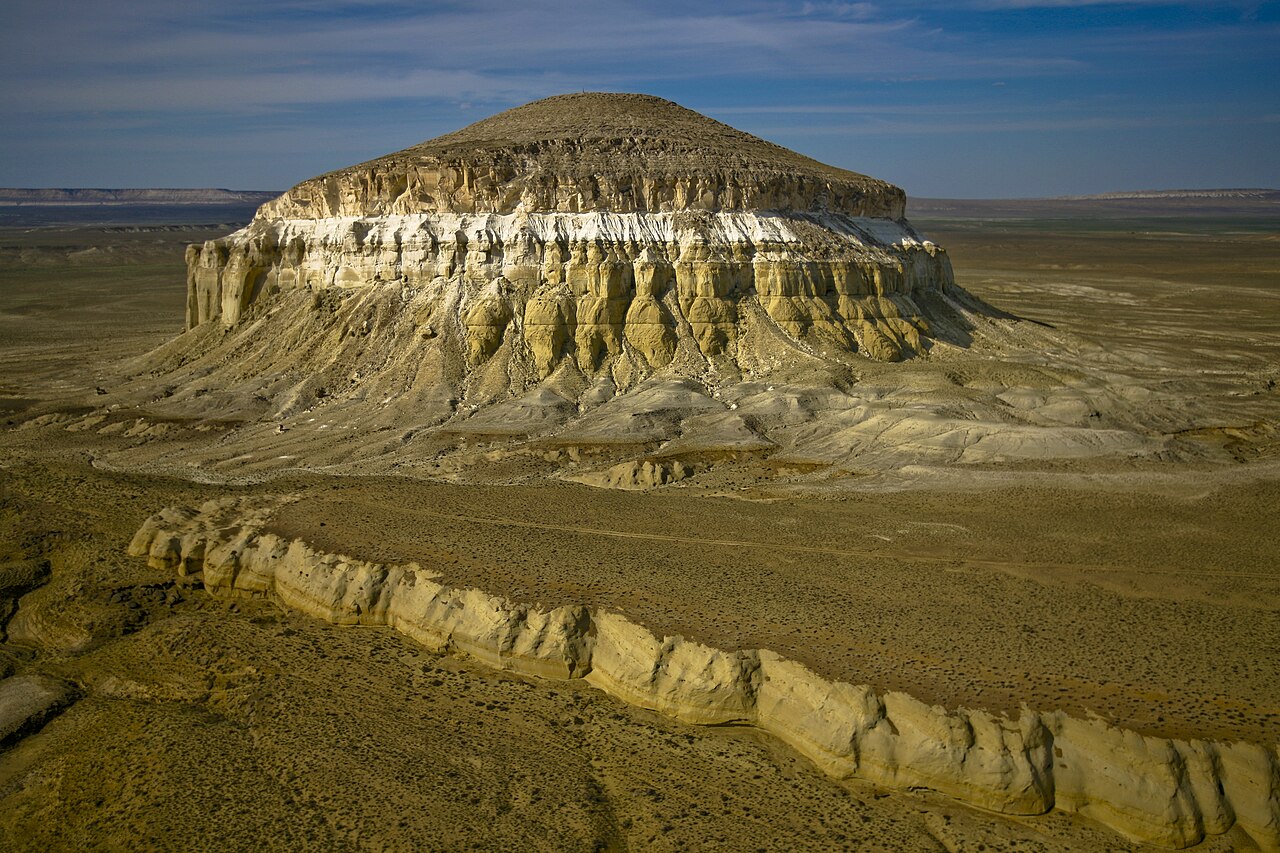
The name comes from Persian — shirqal’eh, “Lion’s Castle” — and you’ll see it rendered as lion’s fortress or lion’s mountain, with one Kazakh outlet attributing the name to Turkmen instead. Either way, the lion is in there.
On the height, let me save you from the internet. Almost every page says 332 metres. Topographic data gives Sherkala an elevation of 307 m with a prominence of 156 m, which makes it the sixteenth highest of 188 named peaks in Mangystau region; its nearest higher neighbour, Zhalgan at 331 m, is under six kilometres away. One widely-read operator page even manages to contradict itself in a single sentence, offering “307 metres tall (332 metres above sea level).” The useful way to describe it: about 300 metres above sea level, and roughly 150 metres above the steppe you’re standing on.
It measures around a kilometre north to south by 650 metres east to west, and walking right around the base takes about an hour — which is, for most people, the correct way to experience it. The shape shifts completely as you go. From one side it reads as a piala, the handleless Kazakh tea bowl, upside down. From another it’s a yurt. From another it’s a sleeping lion with its head on its paws, or something distinctly Sphinx-like. The south and east faces are steep; the north is more eroded, cut with small gorges and caves.
Can you climb Sherkala?
Not casually, and I’d advise against it. Reaching the summit without climbing equipment is described as practically impossible given how steep every side is. A Kazakh blogger who has done it says you need equipment and experience for a chute of roughly fifteen metres near the top, and adds the sentence that should decide it for you: don’t even think about climbing without proper kit, and even with kit it can be dangerous, because the rock is being destroyed by wind and rain. That’s the same friable chalk problem you get all over Mangystau. One travel blog does claim you can scramble up; it’s the outlier, and I wouldn’t bet on it.
Walk the base instead. Locals hold that a wish made while circling the mountain comes true, which is a better use of the hour.
The fortress, the siege and the city next door
There are remains of a medieval caravanserai and a fort on and around Sherkala, traditionally attributed to Jochi, Genghis Khan’s eldest son, at the start of the thirteenth century. Kazakh reporting frames this properly as a belief held by some historians rather than settled fact, and I’d keep it that way.
The siege legend is more fun and probably explains the name. The mountain town was besieged by Astsyz, the Sheikh of Khorezm, after he conquered Mankashlak. Four months in, unable to take it by force, the attackers tunnelled sideways through the rock until they broke into the shaft of the town’s well, cut the bucket rope, and thirst did the rest. In one version the invaders were so impressed by the defence that they named the place the fortress of lions.
Beside Sherkala lie the remains of Kyzylkala, “Red Fortress,” a medieval Silk Road trading settlement. It grew from the tenth century with settlers from Khorezm and declined in the thirteenth, partly after the Mongol conquest of Khorezm and partly because Caspian sea-level change shifted the caravan routes away. Excavation has turned up fortifications, an extensive caravanserai, a mausoleum, three ovens, Oghuz and Khorezm pottery and talc vessels. One striking detail, though it is contested by other accounts: coins have reportedly never been found at Kyzylkala or Sherkala, which would imply the trade here was pure barter. The Arab scholar al-Khwarizmi credits Astsyz with founding the settlement after taking Mankashlak in 1138. Our Silk Road in Kazakhstan guide picks up this thread across the rest of the country.
Sherkala’s own Silk Road role is inferred rather than proven — no firm record exists, but it’s reasonably supposed to have served as a landmark and rest stop on a Caspian branch of the route. Which, standing at the base and looking at it from twenty kilometres away across flat ground, makes obvious sense. You could navigate by that thing.
What else is on the same route
Sherkala is the hub of a small cluster, and this is where a good day becomes a great one:
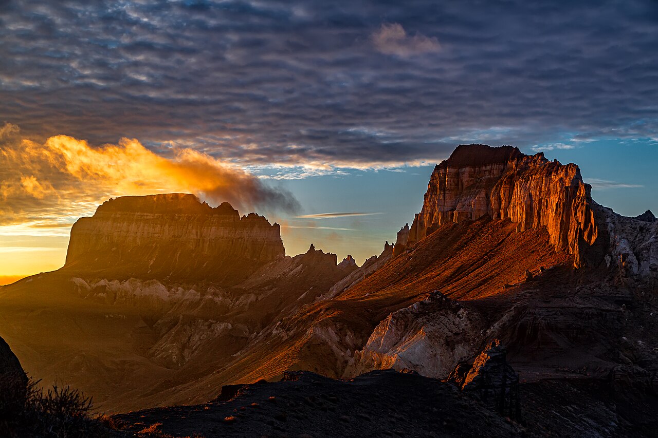
- Airakty (also Zhairakty or Shomanai), the Valley of Castles, about 10 km east. A skyline of eroded limestone buttes that genuinely look like ruined fortresses. It was named and first sketched by the exiled Ukrainian poet Taras Shevchenko, who visited in 1851 — the same man Aktau was named after for 27 years. The limestone was exposed when the Tethys sea floor rose around 40 million years ago. It’s 180 km from Aktau by road, greenest and most photogenic in spring, and tour camps pitch in the valley in peak season.
- Kok-Kala, about 10 km west of Sherkala — purple-grey Jurassic clay hills, a complete change of palette.
- Akmysh oasis, 1.5 km south-west, on a shallow river that was almost certainly a caravan water source.
- Shikh Ata necropolis, abandoned and atmospheric.
- Kogez ethno-village, about 5 km south-east — roughly fifteen yurts with real beds, a small restaurant, showers and toilets, and horse riding. The only proper accommodation in the immediate area.
- Karaman-Ata, 35 km south-west of Shetpe — and this matters, because most itineraries put the wrong underground mosque on this day. Shopan-Ata is 200-plus kilometres south in Karakiya district. Karaman-Ata is the one that belongs here: a large necropolis with medieval gravestones and a mosque cut into a low hillside in three rooms, and now one of the five sites inscribed by UNESCO in 2026.
Do you need a 4×4? The genuinely unresolved question
Here is one place where I can’t give you a clean answer, and I’d rather say so than pick a side.
The case for 4×4: one major operator states flatly that you need one to reach the Torysh cluster, and that an off-road vehicle is necessary to get close to Sherkala’s base.
The case against: the most authoritative independent regional guide publishes an explicit list of the Mangystau sites that require 4WD — Bozzhyra, Kyzylkup, Airakty, Tuzbair and Karynzharyk — and pointedly omits Torysh and Sherkala. Another 2026 guide describes Torysh as “the most accessible geological anomaly” in the region and lists Sherkala’s access as “paved road; visible from highway.”
My read: the tarmac gets you most of the way to both, and the short dirt sections are the variable. In dry weather a high-clearance crossover is probably fine for Torysh and the Sherkala area; a low sedan is asking for sump damage on sharp stones; and after rain the clay makes the question moot for everything. If you want Airakty in the same day, that pushes you firmly towards a proper 4×4. If you’re weighing self-drive at all, read renting a car in Kazakhstan first — and note that Aktau rental contracts have strong opinions about off-road use.
When to go, and what a day costs
Spring, roughly March to May, brings +10 to +25 °C and a briefly flowering steppe. Autumn, September to November, is dry, golden and has the most reliable tracks. Summer, June to August, can hit +45 °C with no shade anywhere on open steppe — if you go then, start at five or six in the morning and be finished by eleven. Winter drops below −10 °C with strong wind. Nights fall fifteen to twenty degrees below the daytime figure year-round, so bring layers whenever you come. Our best time to visit Kazakhstan guide sets this against the rest of the country.
On money: 4×4 rental in Aktau starts around 30,000 tenge a day, a driver with a 4×4 runs roughly 40,000–60,000 tenge a day, and organised two-day tours covering Torysh, Kok-Kala, Sherkala, Airakty and Karaman-Ata start from about US$370 per person. A one-day group tour to Torysh alone is generally the cheapest thing on any Mangystau menu. There are no ATMs beyond Aktau city limits and some operators decline cards, so carry cash. Our guide to organised tours in Kazakhstan explains what guided travel buys you, and Kazakhstan trip costs covers the wider budget.
Frequently asked questions
How were the Valley of Balls stones formed?
They’re concretions. Minerals dissolved in groundwater precipitated in concentric layers around a nucleus inside marine sediment, cementing that patch of rock far harder than its surroundings. When erosion later stripped the softer rock away, the hardened spheres were left standing on the steppe. The process takes millions of years.
Are the stone balls in Kazakhstan dinosaur eggs?
No. Broken concretions show concentric onion-like layering around a small nucleus — the signature of minerals precipitating outward over millions of years, and nothing like the internal structure of an egg. Geologists who have examined them describe giant concretions, and no evidence supports an egg, meteorite or artificial origin.
How old are the Torysh stone spheres?
Genuinely uncertain. No peer-reviewed study of Torysh appears to have been published, and estimates in circulation range from the Jurassic at around 180 million years to the Paleogene at around 50 million. Treat any single confident figure with suspicion.
How big are the stone balls at Torysh?
From marble-sized to roughly four metres across, with plenty in the one-to-three-metre range. Some sit loose on the surface, others are visibly still embedded in the rock and slowly being exposed.
How do you get to the Valley of Balls from Aktau?
About 100–105 km north on asphalt towards Taushyk, then seven or eight kilometres of dirt track. It takes two to two and a half hours. There is no public transport and no signage — go with a driver, a guide, or offline maps and coordinates.
Is there an entrance fee for the Valley of Balls?
No. There’s no ticket office and no published fee at Torysh, Sherkala or Airakty. The only permit anyone needs anywhere nearby is for Karynzharyk, deep in the Ustyurt Nature Reserve near the Turkmen border.
How tall is Sherkala Mountain?
307 metres above sea level, with a prominence of 156 metres — so roughly 150 metres above the steppe around it. The widely-quoted 332 m figure conflicts with topographic data, and at least one source manages to print both numbers in the same sentence.
Can you climb Sherkala Mountain?
Not without climbing equipment and experience, and even then it’s risky: every side is steep, there’s a chute of about fifteen metres near the top, and the rock is actively crumbling under wind and rain. Walking the circuit of the base takes about an hour and is the sensible option.
Why is Sherkala called Lion Mountain?
The name comes from Persian for “Lion’s Castle.” One legend says besieging invaders, having finally taken the mountain town by tunnelling into its well shaft after four months, were so impressed by the defence that they named it the fortress of lions. From certain angles the dome also reads as a sleeping lion.
How many days do you need for Torysh and Sherkala?
One long day out of Aktau covers Torysh, Kok-Kala, Sherkala and Airakty. Two days lets you add Karaman-Ata and camp at Airakty for the light, which is considerably better. Three or more opens up Bozzhyra and the south.
Final thoughts
Torysh is the rare geological curiosity that is more interesting once you understand it, not less. The alien-fleet story is a good story, but the real one — mineral cement quietly building outward from a shell fragment on a sea floor for a few million years, then a landscape wearing away around it — is stranger and considerably older than any invasion.
Pair it with Sherkala, walk the hour around the base, and let the shape change on you as you go. Then push on ten kilometres to Airakty and look at what Shevchenko drew in 1851, more or less unchanged. It’s one of the best single days in Kazakhstan, it costs almost nothing to enter, and if everyone stays on the track and takes their rubbish home it’ll still be intact when the next lot arrive.
For the wider region, start with our Mangystau and the west pillar. If chalk canyons are your thing, Bozzhyra is the other unmissable stop, and Aktau is where you’ll be sleeping either side of it. Both Torysh and Sherkala also feature in our lists of the most beautiful places in Kazakhstan and Kazakhstan’s landmarks, and the wider area is prime off-the-beaten-path Kazakhstan.
Photo credits
Spherical concretions in the Torysh Valley of Balls — Photo: Alexandr Babkin / CC BY-SA 4.0 via Wikimedia Commons. Sherkala from above — Photo: Ashina / CC BY-SA 3.0 via Wikimedia Commons. Airakty-Shomanay, the Valley of Castles, at sunset — Photo: Astrobond / CC BY-SA 4.0 via Wikimedia Commons.


